 Notes explanatory of a map and section, illustrating the geological structure of the country bordering on the Missouri river, from the mouth of the Platte to Fort Benton in latitude 47° 30' N., longitude 110° 30 Notes explanatory of a map and section, illustrating the geological structure of the country bordering on the Missouri river, from the mouth of the Platte to Fort Benton in latitude 47° 30' N., longitude 110° 30  Catalogue of Scientific Papers (1800-1863) - Side 237af Royal Society (Great Britain) - 1869Fuld visning Catalogue of Scientific Papers (1800-1863) - Side 237af Royal Society (Great Britain) - 1869Fuld visning - Om denne bog
 | United States. War Department - 1858 - 690 sider
...of the surrounding country. — (Proc. Acad. Nat. Sci. Pa., March, 1858, p. 19.) By FV HAYDEN : 7. Notes explanatory of a map and section, illustrating...on the Missouri river, from the mouth of the Platte to Fort Benton in latitude 47° 30' N., longitude 110° 30' W.— (Proc. Acad. Nat. Sci., Pa., May,... | |
 | Academy of Natural Sciences of Philadelphia - 1858 - 280 sider
...Trigonopbys rugiceps; " " On the caduciate Urodele Batrachians." By FV Hayden, MD, two, to wit : " Notes explanatory of a map and section illustrating...structure of the country bordering on the Missouri river, etc. ;" "Geological notes on the Mauvaises Terres of White River." By Theodore C. Hilgard, MD, "Classification... | |
 | Academy of Natural Sciences of Philadelphia - 1858 - 378 sider
...Trigonophys rugiceps ; " " On the caduciate Urodele Batrachians." By FV Hayden, MD, two, to wit : " Notes explanatory of a map and section illustrating...structure of the country bordering on the Missouri river, etc. ;" "Geological notes on the Mauvaises Terres of White River." By Theodore C. Hilgard, MD, "Classification... | |
 | United States. Congress. House - 1859 - 746 sider
...portions of the surrounding country. — (Proc. Acad. Nat. Sci. Pa., March, 1858, p. 19.) By FV HAYDEN: 7. Notes explanatory of a map and section, illustrating...on the Missouri river, from the mouth of the Platte to Fort Benton in latitude 47° 30' N., longitude 110° 30' W.— (Proc. Acad. Nat. Sci., Pa., May,... | |
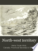 | Henry Youle Hind, Canada. Provincial Secretary's Office - 1859 - 252 sider
...of Lieut. GK Warren. The new Cretaceous and Tertiary invertebrate remains, together with the new * Notes explanatory of a Map and Section illustrating the geological structure of the country on the Missouri River from the mouth of the Platte River to Fort Benton, in lat. 47° 30' N.. long.... | |
 | Henry Youle Hind - 1860 - 540 sider
...in Rupert's Land. * Papers relative to the Exploration of British North America. Blue Book, 1859. t Notes explanatory of a Map and Section illustrating the Geological Structure of the Country on the Missouri River from the Mouth of the Platte River to Fort Benton, in lat. 47° 3CK N., long.... | |
 | Henry Youle Hind - 1860 - 522 sider
...intermediate doubtful strata, so as to include the beds containing Permian * Notes explanatory of a Map nnd Section illustrating the Geological Structure of the Country bordering on the Missouri River, &c., by FV Hayden, MD t Geological Explorations in Kansas Territory, by FB Meek and FV Ilayden, published... | |
 | Geological and Geographical Survey of the Territories (U.S.) - 1872 - 524 sider
...portion of the West that furnishes such a harvest of fossil remains and instructive geological facts as the country bordering on the Missouri River, from the mouth of the Yellowstone to the foot of the mountains above the great falls of the Missouri; and as this country... | |
 | Geological and Geographical Survey of the Territories (U.S.) - 1872 - 542 sider
...portion of the West that furnishes such a harvest of fossil remains and instructive geological facts as the country bordering on the Missouri River, from the mouth of the Yellowstone to the foot of the mountains above the great falls of the Missouri; and as this country... | |
| |